|
|
| As indicated by its name, the canal links the river Marne to the river Rhine. It cuts Saverne
in two parts since 1853, year in which it was put into service. The crossing of the city is therefore constrained,
because you must use one of the three bridges.
The barges wich you can see on the canal were formerly towed by horses, then by small electric locomotives, before they became self-propelled. Coming from Strasbourg, the canal goes through the lands formerly occupied by the Castle's Park. Arrived in Saverne, it goes under the Orangerie Bridge and turns at right angles on the right where it forms the Canal Basin.
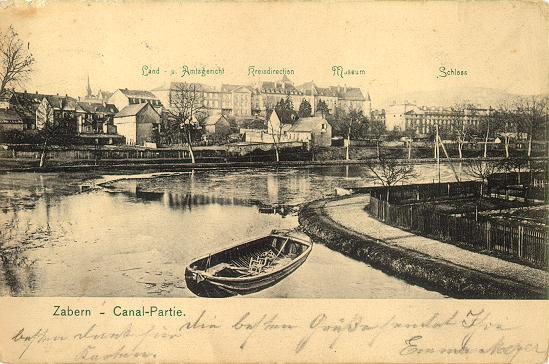
In the basin some buldings are reflected in the water: the Rohan Castle, the subprefecture formerly Episcopal Regency (Kreisdirektion on the postcard), the trial court and the former Episcopal Chancellery (Land- u. Amtsgericht on the postcard)
The canal basin goes along the current Castle's park and makes then a second right angle, on the left, which makes it go towards the centre of the city, along the Canal Quay. The reeds which grew in this turn at that time have disappeared today. They are no more compatible with the today self-propelled barges, which are taller than those of the past and which have screws. Notice on the right, near the wife and her child, the little door topped by a double sloped roof. It's the entrance of the baths that were created in the river Zorn. Today, you can still see, in the wrought iron of the gate, the words "Eingang zum Bad" (Bath Entrance).
The Canal Quay, which leads to the bridge in Main Street and to the lock, was formerly borded with trees. They were knocked down during the restoration of the banks and the enlargement of the canal in the 60's.
[Back to start] [The middle city] [Railway Station and Post Office] [River Zorn] © Thierry Heitmann - 1997-2001 |